The Spatial Units Register is a public record containing alphanumeric and geospatial data about spatial units and is integrated into the Geographic Information System (GIS). The Spatial Units Register data are public and used for the purpose of recording, collecting, exchanging, linking, and processing various types of spatial, statistical, and other data.
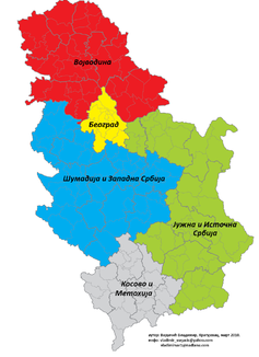
The types of spatial units maintained in the Spatial Units Register include: the Republic of Serbia, autonomous provinces, administrative districts, cities, municipalities/urban municipalities, cadastral municipalities, settlements, local communities, statistical areas and enumeration areas, as well as spatial units defined by the Nomenclature of Territorial Units for Statistics (NSTJ): Serbia - North and Serbia - South (NSTJ1), regions (NSTJ2), and areas (NSTJ3).
The Spatial Units Register data are obtained from the Republic Geodetic Authority, which is responsible for maintaining the Spatial Units Register according to the Law on the Spatial Units Register and Address Register ("Official Gazette of RS", 9/2020).